Clubhouse, Boatshed, Surrounds, Dam & Some 360º Panoramic Views - 2005/06
Photos: Mal Kiely
Page 2 of 3

View from the Clubhouse window across to the dam. October 2006.


This small grove of trees opposite the Clubhouse have really picked up over the last few years. There's been plenty of trees planted over the years to provide some very picturesque, shady camping areas. October 2006

Some of the catamarans parked between the Clubhouse and boatshed, awaiting the return of the water... October 2006

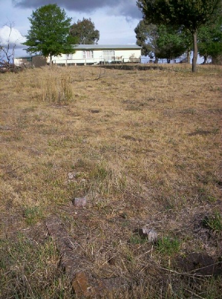
Remains of the old brick BBQ, at the site of the old shelters, first built c.1976. On the grass slope at the front of the Clubhouse.

Looking back up the short slope to the Clubhouse, from where the original shelters stood. The remains of the old brick BBQ are in the foreground.

Looking back down the hill from in front of the Amenities block towards the Boatshed, October 2006


Sailability Central West's Boatshed, June 2006 Built on the site of the original boatshed.
Materials and labour for the sheds' construction kindly donated.

Sailability Boatshed, with the Club Laser awaiting a sail, October 2006

Sailability Boatshed, Clubhouse side. David getting the Club Laser ready for a days' sail, October 2006

A glimpse inside the Boatshed on a sailing day, October 2006 - before the concrete floor went in (c.2008).

Eastern side of the Boatshed, where some further boat storage is planned. October 2006

North side of the Boatshed, with the top of the Flagstaff peeping out over the top of the roof, and the Wind Turbines on the ridge in the background. October 2006

Part of the foundations from the original boatshed.
"Hank, Bob, Fred, Chris. 22 - 7 - 1979"

Late afternoon shadows cast their light upon the track leading down to the water's edge, at the rear of the boatshed.

June 2006: Looking back upland from the sailing clubhouse and boatshed... with some friendly cows - and it was sooooooo dry then! Most of the land in the foreground upto the cows should have been underwater...
Compared to this shot (below), taken in a similar location (behind the boatshed), in October 2011, when the water level was at 80%!!! (Thanks for your approval, Timothy! hahaha!)


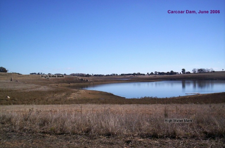
Carcoar Dam, June 2006. Midwinter on a still, cloudless day.
This basin, and the one behind it, are the ones we normally do most of our sailing on. The dam wall is about 2 km's away to the far left.
The water level was sadly at about 20% capacity here.
5 years of drought tend to do that to water levels.

The damside 'beach' rigging area, October 2006. The long strips of rubber matting assist wheelchair access to the pontoon. The Boatshed is directly behind the top of the hill.

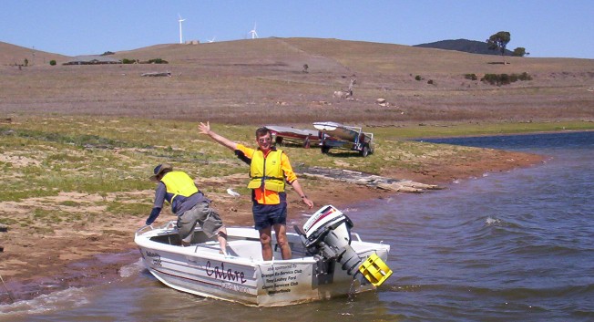
Timothy Hone in one of the Club's motor rescue boats. The temporary boat ramp can be seen snaking up the slope behind him, as can some of the wind turbines on the horizon. October 2006.

The Sailability pontoon and rescue boat at the beach rigging area. The dam was at only 20% capacity in October 2006.

The pontoon at the rigging beach area. The rescue boat at the ready, as is the Sailability harness (at end of pontoon). Access 2.3 "Daybreak" at right. October 2006

THIS is what it looks like when the dam is FULL! (October 1998, John Ford in foreground). That's the original boatshed where the current boatshed now stands. Compare this view to the next photo...

Looking in the same direction as the previous photo. The back of the boatshed, October 2006. No water to be seen anywhere! (Dam level was at only 20% here). Those two trees had water lapping against them in the previous photo in 1998!

It has been worse... the dam was EMPTY in the winter of 1983... looking out from in front of the boatshed, Flagstaff in the foreground. No water to be seen anywhere!!!
Then compare this same view from 2006:


October 2011: Water level 80%!!! Looking out across the water at the northern end of the boatshed... just last year, the walk to the edge of the water was about 200 meters from the top of that concrete ramp!!! Now it's all underwater!Photos: Mal Kiely
Page 2 of 3

View from the Clubhouse window across to the dam. October 2006.


This small grove of trees opposite the Clubhouse have really picked up over the last few years. There's been plenty of trees planted over the years to provide some very picturesque, shady camping areas. October 2006

Some of the catamarans parked between the Clubhouse and boatshed, awaiting the return of the water... October 2006

Remains of the old brick BBQ, at the site of the old shelters, first built c.1976. On the grass slope at the front of the Clubhouse.
Looking back up the short slope to the Clubhouse, from where the original shelters stood. The remains of the old brick BBQ are in the foreground.

Looking back down the hill from in front of the Amenities block towards the Boatshed, October 2006


Sailability Central West's Boatshed, June 2006 Built on the site of the original boatshed.
Materials and labour for the sheds' construction kindly donated.

Sailability Boatshed, with the Club Laser awaiting a sail, October 2006

Sailability Boatshed, Clubhouse side. David getting the Club Laser ready for a days' sail, October 2006

A glimpse inside the Boatshed on a sailing day, October 2006 - before the concrete floor went in (c.2008).

Eastern side of the Boatshed, where some further boat storage is planned. October 2006

North side of the Boatshed, with the top of the Flagstaff peeping out over the top of the roof, and the Wind Turbines on the ridge in the background. October 2006

Part of the foundations from the original boatshed.
"Hank, Bob, Fred, Chris. 22 - 7 - 1979"

Late afternoon shadows cast their light upon the track leading down to the water's edge, at the rear of the boatshed.

June 2006: Looking back upland from the sailing clubhouse and boatshed... with some friendly cows - and it was sooooooo dry then! Most of the land in the foreground upto the cows should have been underwater...
Compared to this shot (below), taken in a similar location (behind the boatshed), in October 2011, when the water level was at 80%!!! (Thanks for your approval, Timothy! hahaha!)


Carcoar Dam, June 2006. Midwinter on a still, cloudless day.
This basin, and the one behind it, are the ones we normally do most of our sailing on. The dam wall is about 2 km's away to the far left.
The water level was sadly at about 20% capacity here.
5 years of drought tend to do that to water levels.

The damside 'beach' rigging area, October 2006. The long strips of rubber matting assist wheelchair access to the pontoon. The Boatshed is directly behind the top of the hill.
Timothy Hone in one of the Club's motor rescue boats. The temporary boat ramp can be seen snaking up the slope behind him, as can some of the wind turbines on the horizon. October 2006.

The Sailability pontoon and rescue boat at the beach rigging area. The dam was at only 20% capacity in October 2006.

The pontoon at the rigging beach area. The rescue boat at the ready, as is the Sailability harness (at end of pontoon). Access 2.3 "Daybreak" at right. October 2006

THIS is what it looks like when the dam is FULL! (October 1998, John Ford in foreground). That's the original boatshed where the current boatshed now stands. Compare this view to the next photo...

Looking in the same direction as the previous photo. The back of the boatshed, October 2006. No water to be seen anywhere! (Dam level was at only 20% here). Those two trees had water lapping against them in the previous photo in 1998!

It has been worse... the dam was EMPTY in the winter of 1983... looking out from in front of the boatshed, Flagstaff in the foreground. No water to be seen anywhere!!!
Then compare this same view from 2006:

By the way... that's the first time the water has been anywhere near that little temporary boatramp since 2001!!! (That was some leftover concrete from building the Sailability boatshed c.2001, and was used as a quick fix to a then-lowering waterline. Little did we all know that the water level would eventually drop to just 4% in 2010!!!)


The sun sets over the peaceful, sparkling waters of Carcoar Dam, from the 'beach' rigging area & pontoon. Water level was at 19% on 22 October 2006

Carcoar Dam Wall, September 2006
At the time of this photo, the water level was at just 20% capacity.
Mount Macquarie in the background, and the windfarm turbines are off to the left.

Carcoar Dam wall, 1 November 2006.

Face of Carcoar Dam, 1 November 2006

They're letting all our water out! The bottom of Carcoar Dams' face, 1 November 2006

View from atop Carcoar Dam wall, 1 November 2006

The power boat section near the dam wall. Public boat ramp is off to the left, wind turbines off to the right. CDSC is up around the next bend in the lake. 1 November 2006
More Clubhouse, Boatshed, Surrounds, Dam & 360º Panoramic Views :
Go to page 1 - Go to page 3


No comments:
Post a Comment